


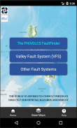
The PHIVOLCS FaultFinder
Description of The PHIVOLCS FaultFinder
The PHIVOLCS FaultFinder is a mobile application that provides users with vital information regarding the distance between their current location and the nearest active fault line. This app, designed for the Android platform, is essential for individuals seeking to understand seismic risks in the Philippines. Users can easily download the PHIVOLCS FaultFinder to access detailed fault information through its user-friendly interface.
The app is built on a web-based Geographic Information System (WebGIS), which utilizes a Spatial Data Infrastructure model. It requires an internet connection to tap into the active fault database maintained by the Philippine Institute of Volcanology and Seismology (PHIVOLCS). The database serves as the backbone for the app, enabling accurate and timely access to fault information. This ensures that users can obtain relevant data regarding geological hazards in their vicinity.
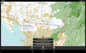
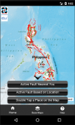
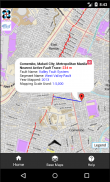
PHIVOLCS FaultFinder allows users to select a location on the map or input an address to receive precise information about the nearest active fault. This feature is particularly beneficial for residents in earthquake-prone areas, as it promotes awareness of potential seismic hazards. By knowing the proximity to fault lines, users can take informed precautions and promote safety within their communities.
A significant aspect of the app is its integration with three different base maps: the Philippine Geoportal Map, Google Maps, and OpenStreetMap. These maps are provided as web services by their respective data owners, thereby offering diverse visual references for users. The Philippine Geoportal Map, specifically provided by the National Mapping and Resource Information Authority (NAMRIA), enhances the app's functionality by delivering authoritative geographic data.
In addition to providing information about fault lines, the PHIVOLCS FaultFinder app allows users to query specific fault trace locations. This capability enables users to gain insights into the characteristics and history of nearby fault lines, contributing to a better understanding of seismic activity in their region. By visualizing the fault traces, users can appreciate the geological landscape that surrounds them.
The application is the result of a collaborative effort between PHIVOLCS, the Department of Science and Technology (DOST) in the Philippines, and the Geological Survey of Japan (GSJ), which is part of the National Institute of Advanced Industrial Science and Technology (AIST). Dr. Renato Solidum, the director of PHIVOLCS, initiated the idea of developing the app, while Dr. Joel C. Bandibas of GSJ led the development process with support from PHIVOLCS research and development personnel.
Users can navigate the app with ease, as it is designed to provide a straightforward and intuitive experience. The interface allows for quick access to essential features without overwhelming users with unnecessary complexity. This focus on usability makes the app accessible for a wide range of individuals, from casual users to those with a specific interest in geological hazards.
Another important feature of the PHIVOLCS FaultFinder is its ability to provide real-time updates. Users can receive notifications about recent earthquake activity in relation to nearby faults. This feature not only enhances user awareness but also supports preparedness efforts in the event of seismic activity. By staying informed, users can better respond to potential threats.
The app is particularly relevant for educators and students studying geology or environmental science. By integrating real-time data with educational resources, the PHIVOLCS FaultFinder serves as a valuable tool for learning about earth sciences and the significance of fault lines. It provides a practical application of theoretical knowledge, allowing users to explore geological phenomena in their local context.
The PHIVOLCS FaultFinder also emphasizes the importance of community awareness regarding earthquake preparedness. By making fault information readily available, the app encourages individuals and families to engage in discussions about safety measures and emergency plans. This can lead to stronger community resilience in the face of natural disasters.
In essence, the PHIVOLCS FaultFinder is a critical tool for those living in regions vulnerable to earthquakes. Its combination of informative features, user-friendly design, and real-time data access makes it an indispensable resource for understanding and navigating seismic risks. By facilitating knowledge about active faults, the app empowers users to take proactive steps in safeguarding themselves and their communities.
The collaboration between PHIVOLCS and international partners highlights the commitment to enhancing public safety through technology. As users explore the app, they gain not only valuable information about geological hazards but also a deeper appreciation for the science behind earthquakes and fault lines.
With the ability to easily download the PHIVOLCS FaultFinder, users can quickly access the information they need to stay informed and safe. The app's design reflects a dedication to fostering awareness and preparedness in the face of natural challenges, ultimately contributing to a more informed public.
The PHIVOLCS FaultFinder - Version 18
(03-12-2024)The PHIVOLCS FaultFinder - APK Information
APK Version: 18Package: com.phivolcs.faultfinder_0Latest Version of The PHIVOLCS FaultFinder
Other versions


Apps in the same category


